Sunday, December 10, 2017

Looking back at 2017

2017 is almost over. And flying season was already over for a month or so. I still might get another flight at Wellfleet, but that just a bonus airtime :-)

So how my 2017 flying season compares to previous years? Simple - it was the best flying season I got so far! ... with the worst flying weather in New England since I started flying... Sounds contradictory, but that's how it was.

In March of this year, when I got to Florida, I had the best flights of my career, with the longest flight being 90 miles. But I was still worrying that those flights wouldn't translate into better flying in New England, and weather in New England wasn't cooperating... it wanted to crush my confidence it seemed.

Almost every weekend was either raining, blown out, or too light. And yet, on Independence Day, my luck suddenly turned, and I got one flight that topped all my personal bests in New England XC flying. Only one single day... so it was a long pause, and then a super awesome flight, and then a long pause again.

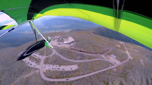
And yet it wasn't over. Mount Washington treated us to a super nice flight. No XC, but the place itself is majestic. I didn't care going anywhere.

And that's how it was - the best flights of my career in the worst flying season :-) I'll take it. I hope the next season is going to be a bit more consistent.

Airtime wise, I got almost the same amount of hours like last year. Thanks to awesome Florida flying weather for that. I am planning to participate in Green Swamp Sports Klassic again in 2018. I am not interested in competition but I do enjoy working the tasks. We'll see how it goes next year...

Here is a video compilation of my season.
Flying Stats:
    Number of flights: 49
    Total Airtime: 42h 40m
    Longest flight: 4h 36m
    Longest distance: 90.2 miles

Tuesday, August 29, 2017

Climbing Higher and Higher

Mount Washington... The highest peak in New England. It is a part of White Mountain National Forest, and that forest stretches for miles in every direction. This is a great area for hiking and mountain biking, maybe not so much for hang gliding.

Mount Washington is known for its unpredictable weather. It's often very windy. Too windy to fly. The way it was explained to me, the only time winds at that mountain are manageable for free fliers is when three high pressure fronts align properly. One right over the region, one pushing from north, and another sitting over Caribbean. That also produces an easterly flow, and that is the only direction we can safely launch/fly at that place.

There are two small fields we can land in. One is right next to Mt Washington Autoroad tollbooth, and another a bit to the north of it, at the beginning of Glen trails.
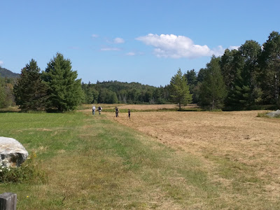
Glen Trails field
All of that makes this site a very challenging, a rarely flown place. I didn't expect to fly there often if ever, so that opportunity fits into a category of hang gliding bucket lists. Gotta do it at least once.

Naturally, H4/P4 advanced rating is required to fly there. Any negative exposure can close this site for us forever. With all high pressure fronts lining up in the last weekend of August, I was thankful that Crystal pushed me to get my H4 rating last year... I guess, I was going to fly that monster of New England after all!

Ilya and I looked at the forecast for Sunday, August 27th. It looked pretty good, but there was some inconsistency with wind direction. We also looked at the logistics, and we would have to leave Morningside around 5AM. Ouch! Not a morning person. Driving for more than 3 hours after just a few hours of sleep - not my idea of fun. We decided to skip Sunday. Monday looked much better anyway. Plus, John Arrison, who few there plenty of times, was going on Monday as well. We needed someone to show us the ropes.

Crystal offered us to stay at her place on Sunday night as it was much closer to the mountain, just an hour twenty minutes away. We packed our gliders, and left Morningside early.

...

Monday morning we had a nice breakfast (thank you Ilya for cooking), and were at the mountain's base around 9am. Bill Gottling and his wife Sally joined us as well. John was with his non-flying friend Bob. We had two drivers to bring our cars down. That simplified things a lot.

It took around 30 minutes to drive up. After parking cars, we walked to the setup area... if you could call it that... Technically, we can launch from anywhere we find suitable, but east facing slope below the lower parking lot is all covered with huge boulders. No place to set up a glider except for one  small patch of grass. That patch of grass was on a pretty steep slope. We could probably fit 3 gliders there at the same time... with some effort.
In the setup area - Crystal, Ilya and John are evaluating conditions
View from the lower part of the setup are. This is our takeoff runway.

Wind was blowing around 10 mph, gusting to 15. Not as forecasted. John seemed unconcerned. I helped him to bring his glider down to the setup area. John put the glider as low as possible on that grassy patch, and I had to hold the glider from sliding down into abyss until John set the control frame up, and we turned the glider over. Now control frame was holding the glider from sliding. With such an angle, he even needed help to tension the crossbar... Turning the glider around when ready to launch would require help as well. 
John is setting up his glider
The whole setup area
Bill followed John's lead, and started setting up his glider. I looked at all of that - wind, slope, boulders... and my desire to launch started to disappear. I was worrying I'd break my glider before I even get off the mountain.  I didn't feel comfortable setting up on a slope like this.
Bill and Sally are bringing down Bill's glider
Bill and John are setting up their gliders. Not much space left.
Sally is waiting for Bill to get flight-ready
Ilya was not happy with what he saw either. He was worrying about a glide over unforgiving terrain if he'd hit huge sink. Crystal was worried about landing in very slotted fields... her shoulder wasn't fully recovered from a recent surgery. So three of us were pretty much ready to drive down... just after we helped John and Bill to launch.

40 minutes later wind started to die down. Nice clouds started to form to the east. An occasional thermal would bring a nice cycle of straight-in breeze. John launched, and went up like a rocket. Bill waited for another cycle, and took off without an issue as well, climbing fast toward the clouds.
John is waiting for a good cycle, with Crystal and Ilya on the wires
(video credit: Sally Gottling)

We looked at each other... Setup area was clear. We still had time, and the day was working really, really well...  John came on the radio, telling us how good condition were, and that we should really give it a try. This was a rare opportunity - don't miss it!

Crystal decided to pass. Too much worry about landing. There will be another day.

Ilya and I helped each other to bring the gliders down, and open them up. We were setting up as fast as we could. I was also worried that by the time we were ready, air might start flowing downhill - a known phenomenon with east facing sites.
Colorful Sport2s taking over Mt Washington glider setup (photo cred: Sally Gottling)
It was probably the fastest glider setup I've done. We were ready in 30 minutes. Ilya went first. There was almost no wind by that time, but he caught a very light cycle and set on a glide away from the mountain. No crazy climb.

(video credit: Sally Gottling)

By the time Crystal helped me to turn the glider around, there was no wind at all. I was looking at the streamer we setup earlier, and it was gently starting to show wrong wind direction. Wonderful. "You are late!", my agitated brain screamed at me.
Crystal and Bob are helping me to turn the glider around  (photo cred: Sally Gottling)
I waited, watching the streamer gently raise up toward the hill, and lower itself again - no wind. I decided that no wind was good enough. It's a Sport, a glider I know well. We'll be fine. It's the highest foot launch for me, 6000' feet MSL, but there is a big drop below launch... enough to get up to speed without an issue.

I balanced the glider on my shoulders, double checked angle of attack, and started my run. I immediately realized that there was no way I would clear the boulder at the edge of the cliff. I started my run too low down the slope. Oh well, no panic. Gently push out, clear the edge, and pull in. Thank you gravity! It doesn't look bad on the video, but Crystal saw right away the predicament I was in, and you can see her reaction. She gave me plenty of grief afterwards as well.
(video credit: Sally Gottling)

What could have I done better? First, start higher up the slope. Two, wait for some breeze coming in. What was my decision making process? I moved down because the slope is very uneven, with hidden holes and rocks. I thought, I found the smoothest path, and consideration for shortening my run didn't enter my mind at the time. I knew there was plenty of a dropoff to help me out, though. As to wind... I already described my decision regarding that. 

Anyway, I was up in the air. Climb slightly but was still too close to the terrain, so I set on a glide away from the mountain. I accepted a possibility of a sledder. It didn't matter that much at the moment.

Ilya was already pretty far away, testing a glide path to the LZ, I guess. He wasn't losing much altitude, but wasn't climbing much either. I set on a glide toward him, but altered my path slightly to go over the auto road. If I sank out, at least I'd take a nice video of that part.... Right, video... I realized that I forgot to start recording. No video of the launch. Oh well. In all that launch anxiety, it was the least of my worries.

I turned the camera on as I was approaching side of the mountain to NE. I felt a smooth transition into a thermal, and banked hard to play with it. A few seconds later, averager on the vario reported 400 FPM up. Awesome! Now realization that I was up in the air at freaking mount Washington started to sink in. Anxiety was gone. I was not only flying over it, I was climbing out!

Camera is on. On a glide out toward auto road.

First thermal

One circle, and vario reported 600FPM. 700, 800, 900! WOW! That was the strongest consistent climb I experienced to date. Smooth, too! No going over waterfalls. Ama-freaking-azing! I reported my crazy climbs on the radio, and saw Ilya gliding back toward launch. Good! We are going to play with that mountain for a bit.   

I couple of minutes later I was at the cloudbase, 1800 feet over launch. This was getting better and better. Now that I didn't have to worry about sinking out, I flew back toward launch to enjoy the views and to get a better video from above.

For the next hour I was going up and down, and up again, gliding toward wildcat mountain and back to launch, chasing Ilya from above, then sinking out and looking at him from below, then getting back up again.
Cloudbase!

Back to launch, a few hundred feet higher

Enjoying the views

Chasing Ilya

As happy as I can be

After an hour of aimlessly flying around, I was getting cold sitting at 7K MSL all the time. My fingers started to beg for some warmth. I need much better gloves for flights like these. Anyway, I decided with all that lift, I can go down to 4K MSL and warm up. Not a bad decision, but I should have paid attention where to do that. Looking at the clouds and staying close to a potential thermal would have helped. But no, I just glided absentmindedly toward LZ, losing altitude.

After I warmed up enough, I tried to get back up... Nope, nothing. Clouds were too far now. I found a thermal right over the LZ, but it was rather weak. Pushing 50-100 FPM maybe. I stayed with it for a half hour, gaining another thousand feet but never finding anything strong. After getting tired with that play, I decided it was time to land.

The landing went smooth enough. Crystal said on the radio that there was no wind on the ground. I looked at the flag near the tollbooth and it was showing due east. The field goes north south. I tried to cut it diagonally, just in case, but almost got short. Not wanting to land in the tall grass, I extended my glide a bit, and had no energy for a good flare. Landed on my feet, though.
(video credit: Crystal Wolfe)

Ilya landed another 20 minutes later. He executed a perfect landing. This birdman can fly, and he certainly can land!

(video credit: Crystal Wolfe)

My flight was 1 hour 42 minutes. Awesomely unexpected day at the most intimidating site in New England. I hope to do it again sometime.

....

Big thanks to everyone who helped on the ground - Crystal, Sally, Bob! And big thanks to John for showing us the ropes, and encouraging us to give this mountain a try.

(photo credit: Sally Gottling)
John, Bill, Max, Crystal, Ilya (photo credit: Sally Gottling)


Here is a couple of videos from that day:

Ilya's video:

And, of course, Skymax Studio:


PS
For geeky curious, here is the recording of my flight:
http://doarama.com/view/1648940


Thursday, July 13, 2017

Orange on the Red, White and Blue

Weather gods stopped smiling on us. After returning from Florida it rained and blew almost every weekend. A few really good days were in a middle of the week. Work got in the way. Gotta pay for that Florida vacation somehow. Overall, I got maybe 2 hours of airtime over 2 months. What a contrast to the last season.

...

On July 4th weekend, forecast was finally pretty good. A bit on a windy side, but no rain 3 days in a row! 

For a couple of days, I launched from 450' hill at Morningside a few times, trying to stay current on my foot launching. No XC flights. It was either too light, or way too windy.

The last day, July 4th, was the most promising. NNW wind 10-15 mph at 3K MSL. Crystal and Ilya decided on a hike to Ascutney. That was too much work for me. I launched from Ascutney a few times in the past, and I didn't feel the amount of effort worth the reward. It can be a fun physical challenge, but I wasn't feeling it this time. I like it better when it's easy.

Aerotowing is much easier for me. I decided to be a wimp and stay at the park. As a challenge, I jokingly promised that I would fly over Ascutney before heading south. With 15mph wind and my slow glider - not likely, but one can dream.

By 12pm the sky looked awesome! Cloud streets stretching all the way south. There was a noticeable drift, but it didn't look too bad. On the ground - wind was right down the runway - perfect. 

I planned my day to launch around 12pm, and I was ready. Let's go!
Go, go, go! Lee Minardi helping me on launch.

The launch went without an issue, and Nick dropped me off in lifting air. I climbed for a few minutes and lost it. Tried going upwind as promised, toward Ascutney. Crossed the river, but found nothing. I was going down pretty fast. It was time to consider plan B - back to the airport and relight.
Crossing the river toward Ascutney
Landing right next to the setup area for a relight

When I landed, Peter Judge was about to tow. No one else was ready. I grabbed a cart and got in line. 10 minutes later I was back at 3000' MSL. This time, I stayed with whatever I got, not trying to be brave and fly to Ascutney. Sorry guys. Maybe some other time. 

After what seemed like a very long time, I finally got to 5500' MSL. Drift was taking me SSE. It took me past the flight park already. I made a few calls on the radio to see if anyone would join me. Got no reply. Decision time... Wind was pushing me south. I either had to go with the wind, or come back to the park. I was gone with the wind.
Finally got established in a thermal, but drifted to the south end of the runway already

The plan was to fly south down Connecticut river. There are plenty of fields alongside of it. The drift was taking me away from the river. I had to constantly fly crosswind back toward it. Climb to 5-6K MSL, pick a cloud close to the river - glide toward that cloud. Zig-zag. Rinse and repeat.

After an hour, I checked how far I was from Morningside. I crossed 16 miles! My first goal was complete - fly farther than 15 miles in New England. Now I was at cloudbase again, and I knew I would get past 20 miles as well. I was not trying to guess beyond that mark... yet.

Past 20 miles mark and at cloudbase! You can see Ascutney in the distance.

The flight was going great so far. The only problem I experienced was my water bladder malfunction. I could barely get any water out of it even though, I knew, it had plenty. I tried to shake it free, thinking that tube got pinched, but the quick connect simply disconnected, leaving me without water for the duration of the flight. Sigh... I pressed on.

Another hour past. I only got low (below 2000' MSL) once, getting lucky a couple of times, finding thermals where I didn't expect them to be. I checked my distance again - 35 miles! Now I was halfway to Tanner-Hiller airport in Massachusetts. I started wondering if I could actually make that far...

Climbing next to Spofford lake in NH. The lake was bustling with activity.

First thing first - I had to fly SE across 3 state forests with no LZs in sight. My instrument told me that I was barely making Orange airport on the other side of those forests. 14 miles stretch. I saw a cloud street roughly halfway between me and Orange - and I went for it. 
At the point of no return. Halfway to Orange airport over large forest with no LZs

It was pretty unsettling to commit to this. I was looking at tiny fields and wondering if I could land in them if worst came to worst. Soon my worries were put to rest. Thermals gods were very generous - I stumbled into a thermal before I got to the clouds. I still had 4000' MSL of altitude (about 3500' above ground). Now I knew I made it at least to Orange. It's another 15 miles to Tanner-Hiller after that

As I set on a final glide to Orange I got somewhat target fixated on that airport. Hoping I could get there high, and I was not looking for another destination. I probably had a better chance crossing to Tanner-Hiller if I flew directly to Gardner airport, a few miles east of Orange. Farther away from Quabbin - more farms with large fields to land in.

Anyway, I got to Orange with 4K MSL to spare, found a weak climb on the south end and tried to climb out. The drift was taking me straight south this time, right toward Quabbin reservoir. More forest around it, not a good direction without a lot of altitude. 
Arriving at Orange airport. Quabbin reservoir ahead.

I lost that thermal at 4200' and decided to fly upwind, staying close to the airport. Clouds were disappearing all around me. I was in a downcycle with not a lot of options to explore. I think, at that point I just gave up, deciding to enjoy my flight as it was and not asking for more.

I was making a circle around airport, monitoring air traffic, and looking for a place to land. I saw a couple of slow moving shadows around my glider's shadow. Hm... other gliders? I couldn't see anyone above me, so I just concentrated on my landing. I picked a large field right outside of the gate. It had a flag right there, telling me wind direction. A perfect landing spot. 

The landing went well. I had plenty of airspeed to cut through a very turbulent layer around 50 feet AGL without much trouble. Flared lightly into headwind, and got a perfect no-stepper landing. I turned the glider around so I could break it down, and then I saw what those shadows above me were - skydivers. It dawned on me that at some point in my flight I was in danger of them hitting me. 

Later I checked my flight path. Considering that skydivers are being dropped upwind I wasn't very close to their most likely drop location. Still, I wasn't aware that Orange had skydiving operation. Another thing to check when preparing a flight plan.

Ready for retrieve 
But I digress... When I landed, a guy driving out of the airport stopped by - curious. We chatted. I was more than happy to brag and tell him more than he wanted to know about hang gliding. Then he drove away. Imagine my surprise when he showed up again, 20 minutes later, with a sandwich and a bottle of cold sparkling water. He refused to take any money for it. "You must be hungry. It was a long flight." People are awesome! For the last 3 years that I started flying XC, I met a lot of nice people. That experience alone worth the effort :-)

The last part of this flight was to figure out how I would get back to my car. A couple of people at the flight park offered to retrieve me if I went XC. I started calling. Nick Caci, our tug pilot, picked up. He was done towing, and was on his way home, passing Keene when I called. He was happy to give me a hand. He towed me up, he picked me up, he drove me back to Morningside. How awesome is that? Thank you, Nick! I owe you one.

Flight statistics: time: 3h21m; launch-to-landing straight line distance: 51.8 miles (83.4 km)

Tuesday, April 11, 2017

Don't Stop Me Now

I'm a shooting star leaping through the sky
Like a tiger defying the laws of gravity
I'm a racing car passing by like Lady Godiva
I'm going to go go go
There's no stopping me
...
So don't stop me now
Don't stop me
Cause I'm having a good time
Having a good time


Amazing weather that we got a week of Green Swamp Sports Klassic competition was coming to an end. Sunday was the only good, flyable, day left until next weekend. So when Tom suggested we should fly somewhere, I was all for it.

With SSW wind in the forecast,  Tom set our goal to Williston airport 70 miles away, with a potential detour waypoint toward town of Dunnellon, to avoid Ocala class D airspace.

Natalia agreed to retrieve us, even though it could be a couple of hours drive (if everything went according to Tom's plan).

Another "green swamper" decided to join us as well. Ricardo Vassmer, flying Bautek Fizz.

The day was looking pretty good toward the afternoon. Cummies were everywhere. It was very hot on the ground, so I delayed putting the harness on until I was near the launch line. Tom and Ricardo launched first as they were ready before me.
The launch went smoothly, and I pinned off early as I felt a nice fast thermal. A few minutes later I was at 4500'. Tom was circling near me as well, and I followed him to optimize my climb to 5200' MSL.
at cloudbase
Ricardo was struggling to get up and landed back at the airport. The thermal we were in was still working, so we decided to wait for Ricardo. While boating around at cloudbase I saw Tom flying straight at me. WTH? I made a diving turn in case Tom was asleep at the wheel, but he radioed that he was going for a better video shot. Thanks Tom. I am still waiting to see that shot.

Ricardo launched second time and climbed to the cloudbase with us. After 30 minutes delay, we finally set on course, going NNW.
Thermalling somewhere on course
Clouds were looking good in all directions with a few blue holes in between, required a detour or two. For the first 10 miles or so it was a pretty easy ride, but we were going a bit too much west. I saw Ricardo higher than me, then lower, then I heard Tom reporting that Ricardo was safe on the ground.

I was flying the way I flew at the comp, pressing on alone each time I felt the thermal was getting soft. I figured, flying the slowest glider - my comrades will catch up, or tell me if there is anything better in a different direction.

I drifted south of prisons, getting lower. Found a climb, and I was trying to get high before I would drift over the prisons. Getting low over those things did not seem like a good idea.

It worked out. I was out of prisons and on a glide toward turnpike. Tom was flying back and forth, getting ahead, flying back or waiting for me. It was hard to find him in the sky sometimes. He couldn't locate me at times either, because my ability to report my location is still pretty rudimentary.

Tom -  "what's your location?"
Max - "I am over the truck stop, at 5k"
Tom - "I am over the truck stop as well, and I don't have a visual on you"

Well, that is because Max was still 3 miles away flying toward the truck stop. From that altitude it looked like the target was right there... but it was still a few minutes away.

When I finally was over the truck stop, I stumbled into 500 fpm climb. Tom was in zero sink several miles ahead on the course line. Then he said something about a bad idea, but he was doing it anyway. Huh? Tom set on a glide toward my thermal. I guess he was getting bored waiting for a slow flying aircraft.

He was late to the party, just as he predicted. The next thing I heard on the radio  "I am low.... *something*.. landing *something*". Ok, there was something about landing, so I assumed Tom was done. I pressed on toward Dunnellon. I had that waypoint in my instrument, but I didn't bother putting Williston in. "Tom will take me there". Right. I guess I will just fly north after Dunnellon, and get as far as I can.
Thermalling over interesting looking housing development
A few miles later - recharging before a lot of forest in front of me, getting to 7k MSL, and staring feeling severely under-dressed - I decided to check if Tom was safe on the ground. Nothing on the radio... Thanks Tom... Then, as a couple minutes passed by,... "Sorry, had my radio off. I am at 4k flying N. What's your location?"

I was so glad to hear that Tom was still flying! I waited for him to catch up. At that point we were right next to Ocala airspace but cruising along at 7k+ MSL, chilled to perfection.

Tom decided that at this altitude, even with Sport 2, we should skip the detour waypoint, and go right over the airspace. He warned me several times that if I was getting low I should bail and glide out toward that field over there. Right on the border of the airspace.

I only gotten as low as 4k, found another climb to 7500'. Circling in a view of the airport was pretty neat. My instrument doesn't have airspace altitude information, and treats all of them as an infinite cylinder, so vario was barking at me, and showing the closet direction out of the airspace for all the time we were passing this place by.
Recharging over Ocala airspace

Tom pointed out that we could see the ocean to the west. It was an amazing view but a tiny gopro couldn't capture it...
Ocean to the west of me
After Ocala, it was a relatively easy glide to Williston, around 18 miles or so.... I cannot believe I am saying that! Just a week ago I had trouble crossing 15 miles mark from launch to landing. The reason it was relatively easy because we were consistently at 7K+ MSL at that point in the flight.

As we were approaching Williston, Tom asked if I was going to land there or keep going? Do you even have to ask, Tom?

I was on a long glide toward the airport, watching planes to takeoff and land. I got there with 4k altitude. Took a small climb while resting a bit, but couldn't climb higher. Day was ending, clouds were thinning.
"Goal" is reached - resting for a bit.
On a glide beyond
There was a cloud to the north of the airport. I went to check it out. Picked a field to land, right next to a road. Got there below 2k feet MSL. Found a very light climb, and was working it patiently. Tom, in his fast ship, jumped to the next line of disappearing clouds and reported strong lift, probably due to convergence with sea breeze. If only I could get where he was...
In the last climb - getting tired.
After what seemed like a very long time, I managed to find that last strong core going all the way up. I was at 7k again, closing on 6pm. Amazing!
Last clouds
Tom warned me to stay right of the cloud line for better lift. I was on a glide, a very long glide, often in weak lift. Weak lift I was passing through didn't have any oomph to circle me up. Tom was doing much better, finding another climb and flying farther.
On a final glide
I stretched my glide as far as I could, but my day was done. Another 20 miles from our original destination, I picked a decent looking field and set for a landing.
Over LZ
Landing didn't go all that well. The glider got turned on final by a cross gust, but continued flying/crabbing straight. That would be fine, but I also saw what looked like boulders on the ground, and I had to flare over them. I hesitated, and didn't flare. Flew over the "boulders" to the grassy area and ended up on my knees, hitting one knee on the basebar. Nothing broken on glider or me, but it hurt. The "boulders" that freaked me out were just grey sand patches in the grass. Oh well...
Sandy "boulders"
Ouch!
All is well that ends well. Enjoying sunset on the ground.
I carried glider to the edge of the field where I got greeted by local kids. They were not terribly impressed by a guy falling out of the sky, but one of them did ask a couple of questions.

I was out of my harness, and was about to text my location to Natalia, as my red truck was already rolling toward me. I was speechless! I have the best retrieve in the world!
In the LZ. Finishing up breaking down the glider.
As I broken my glider down, Tom finally landed, an hour after my landing. He was another 15 miles north. We loaded my glider on the truck and went to pick up Tom.
Tom and I showing off our coordinated attire - Morningside T-Shirts
Two thumbs up  to an amazing day and an amazing retrieve 
Tom treated Natalia and I to a nice dinner at Great Outdoors restaurant in High Springs. A very nice restaurant that was still open late Sunday night. Great ending to an amazing day of flying.
...

This flight was all my personal bests for XC distance and XC flight time. I couldn't believe I flew that far and for that long. Thank you Tom Lanning for taking me on this adventure! You are the best! I also hope all this translates into better XC flying back home in LZ-deprived New England.

Recording of my flight:
    https://ayvri.com/scene/8dk3nyv15x/ckclbc97o00012a6lehwvjt8o

Flight stats:
    http://www.paraglidingforum.com/leonardo/flight/1593394